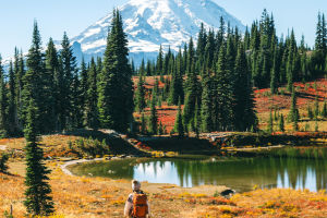
Spring has arrived, and Seattle is finally transitioning into its most comfortable season of the year.
After enduring a long winter of cold and dampness, now is the perfect time to embrace nature, stretch your legs, and reconnect with the outdoors.
A hike on Mount Rainier offers the ideal escape, where you can traverse trails, admire waterfalls, and lose yourself in the beauty of Washington’s wilderness. Here are ten highly recommended Mount Rainier hiking trails, all offering stunning views and suitable for day trips.
Myrtle Falls Skyline Trail
This short but scenic trail leads to one of the most iconic spots in Mount Rainier National Park—Myrtle Falls. While parts of the trail are steep, it’s one of the easiest trails on Mount Rainier. The reward? A breathtaking view of cascading waterfalls that makes every step worthwhile.
- Distance: 0.8 miles
- Elevation Gain: 150 feet
- Difficulty: Easy
- Location: Paradise (South Entrance)
- Coordinates: Ashford, WA 98304, United States
Alta Vista Trail
This trail is perfect for families, with its flat terrain and easy accessibility. Starting from the parking lot, hikers can enjoy glimpses of Mount Rainier and Cascade Falls along the way. Short on time? This trail lets you experience the beauty of Rainier without a long commitment.
- Distance: 1.8 miles
- Elevation Gain: 616 feet
- Difficulty: Easy
- Location: Paradise (South Entrance)
- Coordinates: Washington 98304, USA
24 Hours in Mount Rainier National Park: Hiking the Skyline Trail, Seeing 5 Waterfalls & More
Video by Through My Lens
Bench and Snow Lake Trail
Secluded and less crowded, this trail is a summer favorite. It winds through a shaded forest and ends at two picturesque lakes, where you can capture postcard-worthy views of Mount Rainier. Camping enthusiasts can even set up by the lakeshore.
- Distance: 2.2 miles
- Elevation Gain: 446 feet
- Difficulty: Easy
- Location: Paradise (South Entrance)
- Coordinates: Packwood, WA 98361, United States
Skyline Trail Loop
One of the most popular trails in Washington, this loop offers a variety of experiences in every season. Spring brings cascading streams, summer is vibrant with wildflowers, autumn offers rich hues, and winter transforms it into a snowy wonderland. On clear days, you can spot Mount Adams, Mount St. Helens, and Mount Hood.
- Distance: 6.2 miles
- Elevation Gain: 1,788 feet
- Difficulty: Moderate
- Location: Paradise (South Entrance)
- Coordinates: Ashford, WA 98304, United States
Bench and Snow Lake Trail
High Rock Lookout
This trail leads to one of the best vantage points on Mount Rainier, offering panoramic views. Its steep incline and rapid elevation gain make it a challenging but rewarding hike. Note that the trail can be muddy at the start, so it’s best visited during the summer.
- Distance: 3.2 miles
- Elevation Gain: 1,299 feet
- Difficulty: Moderate
- Location: Near Ashford, WA
- Coordinates: Ashford, WA 98304, United States
Naches Peak Loop
This trail is famous for its wildflowers and crystal-clear ponds reflecting Mount Rainier’s silhouette. It’s a favorite for picnics, with scenic stone benches and grassy spots offering tranquility in nature.
- Distance: 3.3 miles
- Elevation Gain: 636 feet
- Difficulty: Moderate
- Location: Sunrise (East Entrance)
- Coordinates: Pacific Crst Trl, Naches, WA 98937, United States
High Rock Lookout
Silver Falls Trail
Perfect for waterfall enthusiasts, this trail showcases the harmony of water, rocks, and forest. The blue-green hues of the falls make this one of the park’s most beautiful routes. Early summer is the best time to visit, and the campsite nearby is ideal for multi-day stays.
- Distance: 4 miles
- Elevation Gain: 705 feet
- Difficulty: Moderate
- Location: Paradise (South Entrance)
- Coordinates: Washington, USA
Emmons Moraine Trail
While this trail appears lengthy, it connects a variety of viewpoints, making it a highlight reel of Mount Rainier’s landscapes. Whether you complete the trail or turn back midway, you won’t miss much. It’s also a quieter option for those seeking solitude.
- Distance: 4.1 miles
- Elevation Gain: 931 feet
- Difficulty: Moderate
- Location: Paradise (South Entrance)
- Coordinates: Washington 98304, USA
Fremont Lookout Trail
This trail begins on the bustling Sunrise route and leads to a historic fire lookout built in 1930. With no shade along the way, it’s best to avoid this hike in summer’s heat. Instead, enjoy this trail during cooler seasons as it winds toward distant peaks.
- Distance: 5.7 miles
- Elevation Gain: 1,118 feet
- Difficulty: Moderate
- Location: Sunrise (East Entrance)
- Coordinates: Ashford, WA 98304, United States
Tolmie Peak Trail
A standout trail on Mount Rainier, this hike takes you to a more remote area of the park. The gradual incline makes the climb manageable, rewarding hikers with stunning views at the summit. For an extra treat, detour to Eunice Lake for a relaxing picnic. Just remember to pack insect repellent, as mosquitoes can be a nuisance.
- Distance: 5.6 miles
- Elevation Gain: 1,541 feet
- Difficulty: Moderate
- Location: Carbon River (Northwest Entrance)
- Coordinates: Washington 98304, US


